The White Mountains Trail System (WMTS) offers a variety of trail opportunities, ranging from scenic beauty to diverse trail skill levels. It is a series of more than 200 miles of trails built through a partnership between the Lakeside Ranger District and White Mountains TRACKS. The system is designed for non-motorized travel: hiking, mountain biking, and equestrian use. Building new trails and maintaining existing trails is accomplished by the White Mountains TRACKS trail crew working from April to October. Weather permitting, volunteers meet for approximately two hours of trail work each week.
Distances are expressed in miles for a complete loop trail. If the trail is not a loop, it is indicated as one-way. Shortcuts, which create short/long loops, show the distance from the trailhead and back using a shortcut trail.
Difficulty ratings are separated by mode of transportation. The US Forest Service takes the following criteria into account:
Trailheads with limited parking are small cinder pads with little to no turning radius for a trailer. Larger trailheads will accommodate several cars and trailers.
Click here to access the GPX file and PDF maps. The trailheads each have a map box with maps as well. The trailhead kiosk also has a map you can photograph and a QR code with access to the website’s trail system map. You can also obtain printed maps from the Lakeside Ranger District and from visitor centers and otherplaces with visitor information.
Forest-maintained roads provide access to trailheads. During the winter and summer rainy seasons, these roads may be impassable or difficult to drive. Contact the Lakeside Ranger District for road conditions.
Mileage figures originate from the Show Low Post Office for trails close to Show Low. Mileage figures originate from the Lakeside Ranger District for trails closer to Pinetop-Lakeside. GPS coordinates provide the location at the trailhead.
Diamonds with dots: Yellow dots indicate a short route back to the trailhead. Green dots indicate a connector trail to another WMTS loop trail. Red Dots indicate a vista trail.
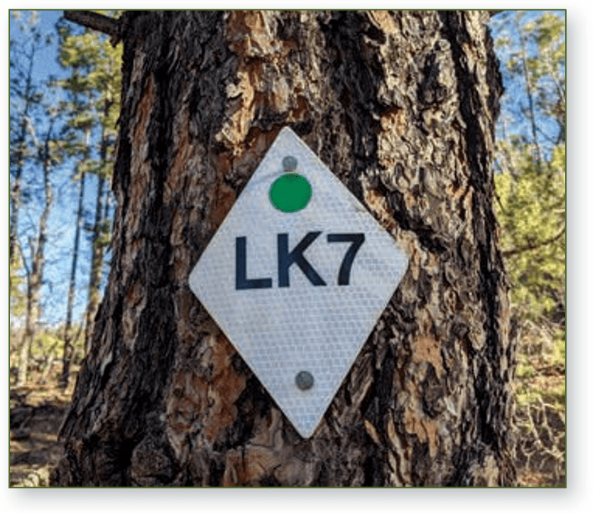
Coded Trail Diamonds: White diamonds with a location code (letter and number, e.g., LK1, LK2) are located approximately every ¼ mile. In case of an emergency call 911. The location code provides your exact GPS location.
Marking the trail: The trails frequently follow old logging roads and may cross roads open to vehicular traffic. Watch for the trail diamonds to ensure you stay on the marked trail.
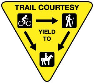
While you’re on the trail, don’t forget trail etiquette. Visitors are reminded to use the trail system safely and follow trail etiquette. Mountain bikes should yield to all users, hikers should yield to horses, and horses always have the right-of-way.